


For World Engineers Day, EnviroScience is spotlighting its own Water Resources Engineer and resident storm chaser, Kevin Wienhold, P.E., and his recent contributions in the fields of hydrology and remote sensing. His work using unmanned aerial vehicles (UAVs or “drones”) to create highly detailed and accurate flood maps in near-real-time was recently published in the Journal of Hydrology [1] this July.
The study, which was funded by the National Science Foundation, consisted of a multi-disciplinary, multi-institutional collaboration between Kevin’s alma mater, Fang Research Group of the University of Texas at Arlington (UTA), and several other universities and public agencies. During the 2020 – 2022 Atlantic hurricane seasons, Kevin established and monitored dozens of watchpoints within major urban areas susceptible to storm surges and flash flooding.
In the hours leading up to a probable flood, Kevin deployed near the path of the hurricane with a rapid response team equipped with UAVs, multi-spectral sensors, and traditional surveying equipment to capture perishable flood-related data. Kevin utilized the data to develop a new method for measuring the impacts of floods on critical infrastructure and to assist first responders with road closures and identifying public safety hazards. The pilot study was proven to be effective for a town in North Carolina undergoing flooding during Hurricane Zeta.
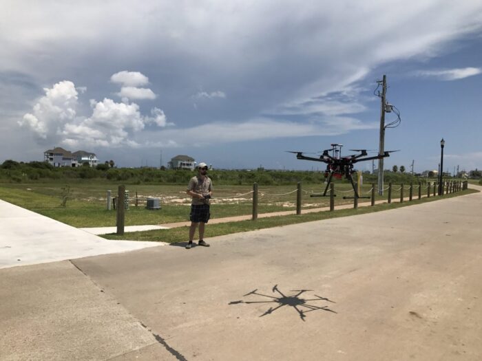
Kevin Wienhold Collects Pre-Hurricane Data with UAV
The remote identification of flood hazards has traditionally been achieved using satellite imagery or a network of ground-based sensors. Actionable data from satellites is often restricted by cloud cover, low image resolution, and overpass frequency. Ground-based sensors such as surveillance cameras can provide detailed images but are fixed and limited in their locations. UAVs are now bridging the gap between static sensors and satellites by providing low-cost, high-resolution and rapidly-deployable monitoring platforms. Difficulties remain, however, in translating this high-quality data into accurate floodwater measurements in real-time.
To address these challenges, Kevin’s method uses a feature-detecting algorithm to isolate and extract floodwater pixels from a multi-spectral aerial dataset. The novelty of the method lies in the ability to adapt the algorithm to the unique spectral properties of the floodwater, which varies with depth, turbidity, sediment concentration and composition, as well as lighting conditions and the presence of shadows. By leveraging photogrammetry (3D measurements from photos) and existing elevation datasets, the floodwater extent is then converted to flood water depth which is ready for operational use within a few hours of collecting the data.
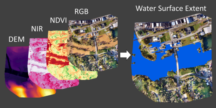
2D Multispectral Maps Used to Delineate Floodwater Extent
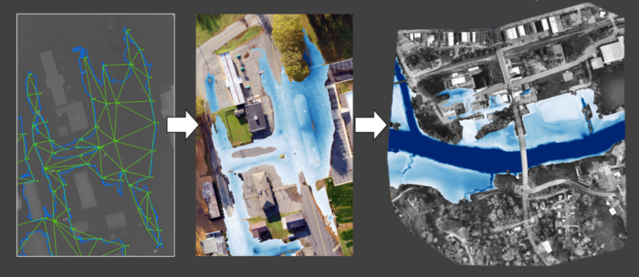
3D Elevation Map Used to Convert Floodwater Extent to Depth for Hurricane Zeta
This new method is expected to enhance the precision of flood modeling while supporting better decision-making in flood management. The pilot study led to direct collaboration between its researchers and several municipalities—including local fire departments, law enforcement, the Army Corps of Engineers Field Research Team, U.S. Geological Society staff, city planners, and first responders. The practical demonstration during Hurricane Zeta helped provide the necessary foundation from which to promote this technology as an efficient and cost-effective flood mapping tool that may one day be used by city planners and emergency responders.
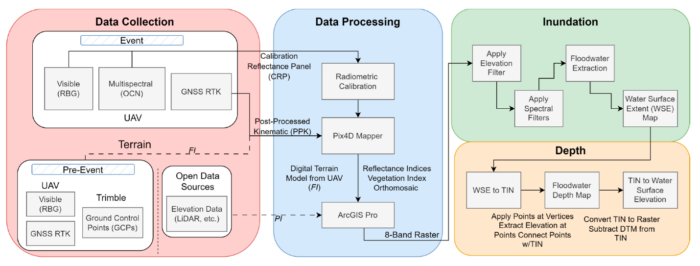
Flowchart of Fully-Integrated Method for Flood Inundation and Depth Mapping
Citation:
Wienhold, K.J.; Li, D.; Li, W.; Fang, Z.N. Flood Inundation and Depth Mapping Using Unmanned Aerial Vehicles Combined with High-Resolution Multispectral Imagery. Hydrology 2023, 10, 158. https://doi.org/10.3390/hydrology10080158
Few environmental firms in the country retain EnviroScience’s degree of scientific know-how, talent, and capability under one roof. The diverse backgrounds of our biologists, environmental engineers, scientists, and divers enable us to provide comprehensive in-house services and an integrated approach to solving environmental challenges—saving clients time, reducing costs, and ensuring high-quality results.
Our client guarantee is to provide “Excellence in Any Environment,” meaning no matter what we do, we will deliver on our Core Values of respect, client advocacy, quality work, accountability, teamwork, and safety. EnviroScience was created with the concept that we could solve complex problems by empowering great people. This concept still holds true today as our scientists explore the latest environmental legislation and regulations and incorporate the most up-to-date technology to gather and report data.
EnviroScience expertise includes but is not limited to aquatic surveys (including macroinvertebrate surveys and biological assessments); ecological restoration; ecological services (including impact assessments, invasive species control, and water quality monitoring); emergency response; engineering and compliance services; endangered mussel surveys; laboratory and analysis; stormwater management; threatened and endangered species; and wetlands and streams (including delineation and mitigation). Further, EnviroScience is one of the few biological firms in the country that is a general member of the Association of Diving Contractors International (ADCI) and offers full-service commercial diving services.