Unlock Environmental Clarity with GIS Expertise
Our Geographic Information Systems (GIS) Services
 Geographic Information Systems (GIS) are more than just mapping tools—they’re essential to effective environmental consulting. At EnviroScience, our GIS Services for environmental consulting combine deep ecological knowledge with hands-on GIS expertise to transform complex spatial data into actionable insights.
From mapping accuracy and AI-powered analysis to cloud-based collaboration, we deliver geospatial solutions that support permitting, restoration, and regulatory compliance—both in the field and at your desk.
Why GIS Expertise Is Essential for Environmental Projects
Top firms stress that successful environmental outcomes depend on visual clarity, regulatory compliance, and data-integrated decision-making.
 Land-use & habitat mapping for site assessments and restoration planning
- Hydrologic modeling & stormwater analyses to anticipate permit constraints
- Regulatory overlays enabling wetlands, streams, and threatened-species impact assessments
By embedding GIS into every project phase—from field data collection to regulatory strategy—you reduce risk, shorten timelines, and enhance stakeholder confidence.

How EnviroScience Elevates GIS Capabilities
INTEGRATED ENVIRONMENTAL FOCUS
Unlike GIS-only vendors, our in-house scientists, restoration experts, and compliance professionals collaborate seamlessly to ensure spatial outputs are not only accurate but contextually informed.
ADVANCED SPATIAL ANALYTICS
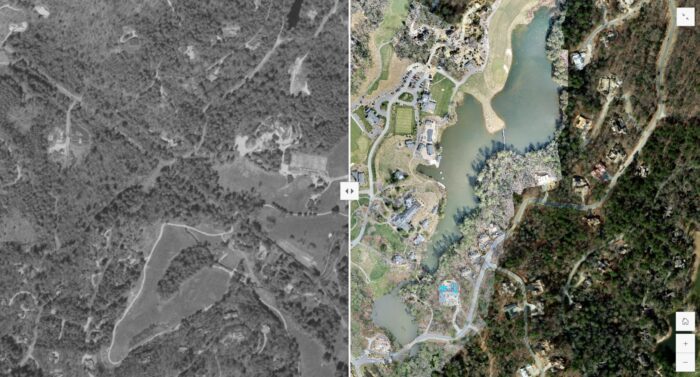
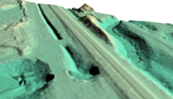
We deploy AI tools, LiDAR, and drone-acquired imagery to deliver detailed terrain models, habitat change detection, and high-resolution spatial insights—all designed for real-world environmental use.
CLOUD-ENABLED COLLABORATION & DASHBOARDS
Our end-to-end GIS solutions range from static maps to interactive web apps, enabling illustrative storytelling for public meetings and real-time access to key metrics by permitting staff.
FIELD-PROVEN DATA COLLECTION
Equipped with GPS/GNSS, ArcGIS Field Maps, and Survey123, we ensure data accuracy and integration from the field—eliminating costly post-processing and improving project confidence.

Why Our Approach Works Better
 REGULATION-READY DELIVERABLES
Streamline your wetland delineations, ESA compliance mapping, and permit submittals with spatial outputs designed to meet regulatory standards.
SCALABLE TO YOUR PROJECTS
Whether evaluating small stream networks or modeling regional watersheds, our GIS workflow adapts—saving you from paying for unnecessary complexity.
EXPERT-LED INSIGHT
Unlike firms that subcontract GIS, our integrated model ensures continuity, accuracy, and accountability—from data collection to deliverable hand-off.
TECH SAVVY, CLIENT-SMART
We don’t just use ArcGIS Pro; we leverage the latest GIS trends—cloud GIS, machine learning classification, and mobile data collection—for smarter, more efficient outcomes.
Real-World Applications & Benefits
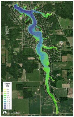
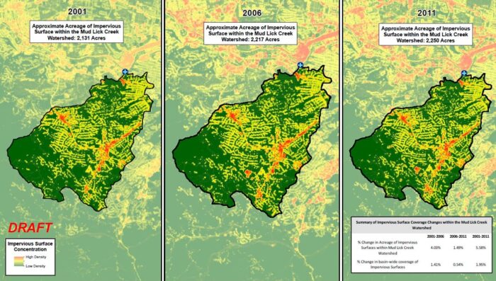
 WATERSHED RESTORATION & HABITAT MODELING
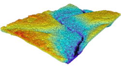
Implement hydro-spatial modeling that identifies sediment hotspots and informs sediment control strategies—crucial for restoration and permit readiness.
WETLAND DELINEATION & ESA COMPLIANCE
Generate precise geospatial maps that expedite permit reviews and reduce field survey back-and-forth.
FIELD-TO-DESK ACCURACY
Utilize GPS/GNSS and ArcGIS mobile tools to deliver survey-grade spatial data—ensuring confidence in every coordinate.
Stay Ahead with the GIS Expertise at EnviroScience
While leading GIS vendors focus on software and platforms, EnviroScience focuses on applied environmental geospatial outcomes using best-in-class tools:
- AI-integrated analysis for feature detection and change monitoring
- Cloud dashboards for real-time access and stakeholder transparency
- Mobile data collection to reduce time and improve mapping precision
Ready to Take the Next Step?
 If you need better spatial insight for permitting, restoration, or environmental planning, explore our GIS Services and discover why EnviroScience is a trusted partner for clients across the country. Our team combines deep environmental expertise with advanced geospatial tools to turn complex data into clear, actionable results.
Whether you’re mapping a sensitive wetland, modeling watershed runoff, or developing site visuals for stakeholder engagement, we’ll work with you to deliver accurate, regulation-ready solutions that move your project forward—with clarity and confidence.
Few environmental firms in the country retain EnviroScience’s degree of scientific know-how, talent, and capability under one roof. The diverse backgrounds of our biologists, environmental engineers, scientists, and divers enable us to provide comprehensive in-house services and an integrated approach to solving environmental challenges—saving clients time, reducing costs, and ensuring high-quality results.
Our client guarantee is to provide “Excellence in Any Environment,” meaning no matter what we do, we will deliver on our Core Values of respect, client advocacy, quality work, accountability, teamwork, and safety. EnviroScience was created with the concept that we could solve complex problems by empowering great people. This concept still holds true today as our scientists explore the latest environmental legislation and regulations and incorporate the most up-to-date technology to gather and report data.
EnviroScience expertise includes but is not limited to aquatic surveys (including macroinvertebrate surveys and biological assessments); ecological restoration; ecological services (including impact assessments, invasive species control, and water quality monitoring); emergency response; engineering and compliance services; endangered mussel surveys; laboratory and analysis; stormwater management; sustainability services; threatened and endangered species; and wetlands and streams (including delineation and mitigation). Further, EnviroScience is one of the few biological firms in the country that is a general member of the Association of Diving Contractors International (ADCI) and offers full-service commercial diving services.